Portland International Jetport (Portland International Jetport)
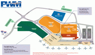
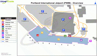
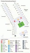
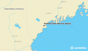
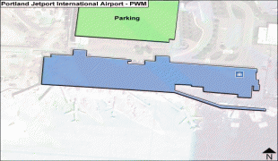
Portland International Jetport is a public airport two miles (3 km) west of downtown Portland, Maine, United States. It is owned and operated by the City of Portland. A portion of the Jetport's property, including the main runway, is located within the neighboring city of South Portland. PWM covers 726 acres (293 ha) of land.
The airport is the busiest in the state. In 2018, the jetport handled more than two million passengers for the first time, breaking the previous record of 1.86 million set in 2017.
The Jetport has benefited from service by low-cost carriers such as Southwest Airlines and JetBlue, as well as Portland's increased popularity as a tourist destination. A survey conducted in June 2011 found PWM to be the most affordable airport in the region, and the third most affordable in New England.
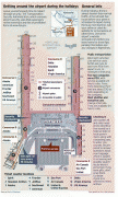
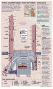
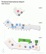
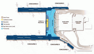
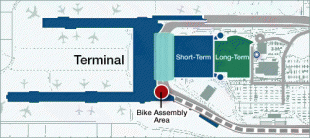
In October 2011, PWM completed a $75 million renovation and expansion of its terminal to allow more airline service and more amenities for passengers.
In 2020, PWM received $4.5 million in federal funds to construct a 1200 ft taxiway connecting runways.
The airport is the busiest in the state. In 2018, the jetport handled more than two million passengers for the first time, breaking the previous record of 1.86 million set in 2017.
The Jetport has benefited from service by low-cost carriers such as Southwest Airlines and JetBlue, as well as Portland's increased popularity as a tourist destination. A survey conducted in June 2011 found PWM to be the most affordable airport in the region, and the third most affordable in New England.
In October 2011, PWM completed a $75 million renovation and expansion of its terminal to allow more airline service and more amenities for passengers.
In 2020, PWM received $4.5 million in federal funds to construct a 1200 ft taxiway connecting runways.
| IATA Code | PWM | ICAO Code | KPWM | FAA Code | |
|---|---|---|---|---|---|
| Telephone | Fax | ||||
| Home page |
Map - Portland International Jetport (Portland International Jetport)
Map


Country - United_States
 |
 |
| Flag of the United States | |
Indigenous peoples have inhabited the Americas for thousands of years. Beginning in 1607, British colonization led to the establishment of the Thirteen Colonies in what is now the Eastern United States. They quarreled with the British Crown over taxation and political representation, leading to the American Revolution and proceeding Revolutionary War. The United States declared independence on July 4, 1776, becoming the first nation-state founded on Enlightenment principles of unalienable natural rights, consent of the governed, and liberal democracy. The country began expanding across North America, spanning the continent by 1848. Sectional division surrounding slavery in the Southern United States led to the secession of the Confederate States of America, which fought the remaining states of the Union during the American Civil War (1861–1865). With the Union's victory and preservation, slavery was abolished nationally by the Thirteenth Amendment.
Currency / Language
| ISO | Currency | Symbol | Significant figures |
|---|---|---|---|
| USD | United States dollar | $ | 2 |
| ISO | Language |
|---|---|
| EN | English language |
| FR | French language |
| ES | Spanish language |